In the wake of this summer’s devastating floods in the Midwest, more and more people are recog-nizing that levees and dams may not be the only way—or even the best way—to deal with floods. Regardless of the measures taken, most floodplains will ultimately flood, and we might do better to work with this natural cycle—and minimize damages—than to work against it. Besides making good economic and hydrologic sense, a flood policy that relies less on structural measures such as dams and levees is great news for the environment. Instead of large, ecosystem-altering projects, a non-structural approach works by protecting nature’s flood-control systems, offering low-cost flood control and environmental protection at the same time.
Natural Flood Control
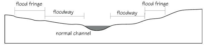
The engineering terms for segments of a river basin.
Nature’s flood-control system begins in the uplands of watersheds, where forests and wetlands can absorb tremendous quantities of rainfall. Trapped in the soft soils and marshes, much of the rainfall naturally works its way through many layers of earth and rock into the underground aquifers. Human development in these upland areas has gradually reduced their absorption capacity. Paving and soil compaction increase run-off into streams and rivers. This effect is blamed for much of the flash-flooding in developed areas that accounts for a high percentage of the flood-related fatalities.
Once flood-level waters have entered the river system, floodplains are the buffers that collect and hold excess water until the river has room to carry it again. Hydrologists distinguish between the
floodway, or expanded channel in which water flows during floods, and the flood
fringe, where overflow water collects but doesn’t flow much (see diagram). A portion of the flood fringe is in the form of overflow wetlands, where periodic flooding feeds rich ecosystems and increases the recharge rate of aquifers.
For many of the same reasons that make floodplains such important ecosystems, they are preferred for many human pursuits. Riverine wetlands in Iowa, drained in the last century, became some of this country’s most productive farmland. Being flat, floodplains are easy to build on and often provide more temperate climates than the surrounding hills. Except when flooded, they can be attractive places to live and work.
Because of this attraction, severe flooding in the Lower Mississippi River Valley in 1928 had devastating consequences. Following this event, the federal government decided to invest in flood control, and a massive national program of dams, levees and floodwalls was initiated. According to a Federal Emergency Management Agency (FEMA) report, the government spent over $7 billion between 1936 and 1965 for structural flood control projects. While proponents of flood-control public works projects point to significant economic savings from avoided floods, the damages from flooding both in dollars and in human lives increased throughout the period and have continued to grow since.
There are many reasons for the continued destruction from flooding in spite of the large federal investment. Overall, the issue is one of replacing a natural flood-control mechanism that interacts in many complex ways with the environment, with a single-minded approach that solves some problems while causing others. “Levees are a narrowly focused solution, providing a specific benefit without addressing many of the costs,” says Jon Kusler, director of the Association of State Wetland Managers.
The Problems With Levees
By constructing levees to keep water out of the floodplains, we deny the river its natural time-delay mechanism of saving some of the water to carry downstream later. Instead, the water is forced to continue moving downstream all at once. As a result, it moves higher and faster, causing more damage. While levees can be effective at protecting an immediate area, using them extensively along a river raises flood levels everywhere, increasing the danger to areas that otherwise might have been safe.
An estimated 25,000 miles of levees have been built in the United States, about 10,000 miles of which were built by the U.S. Army Corps of Engineers. The Corps of Engineers designs its flood control structures to withstand floods of a particular expected recurrence, such as the 100-year or 500-year flood. Many privately constructed levees are not built to any particular standard, however, and they provide what may be a false sense of security. Even levees that were designed to contain floods up to and including the hypothetical 100-year flood may no longer provide that capacity due to changing hydrologic conditions.
Besides changes upstream that can raise flood levels, over time levees can raise the river locally as well. Where a river is contained by levees, sediments that might normally be deposited in the floodplain during flood events settle in the river channel instead, effectively raising the river’s bottom. If the levees are not raised as well, the amount of water that the channel can contain is gradually reduced, making levee failure more likely. These changing conditions help to explain how 31% of the $2.6 billion in flood insurance claims paid by the National Flood Insurance Program between 1978 and 1987 went for flooding outside of the mapped 100-year floodplain. Mapping and stormwater management are failing to keep up with changing rivers and urbanization.
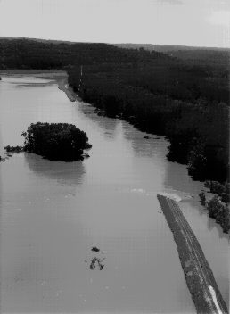
A washed-out levee in St. Charles County, Missouri
Mike Wright, Missouri Highway and Transportation Department
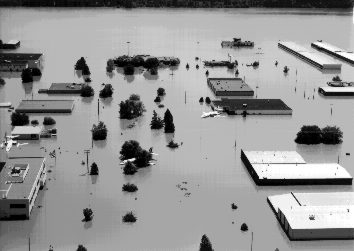
Spirit of St. Louis Airport in Chesterfield, Missouri
Mike Wright, Missouri Highway and Transportation Department
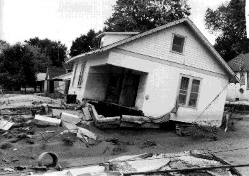
House dislocated by floodwater after levee break in N. Jefferson City, Missouri
Mike Wright, Missouri Highway and Transportation Department
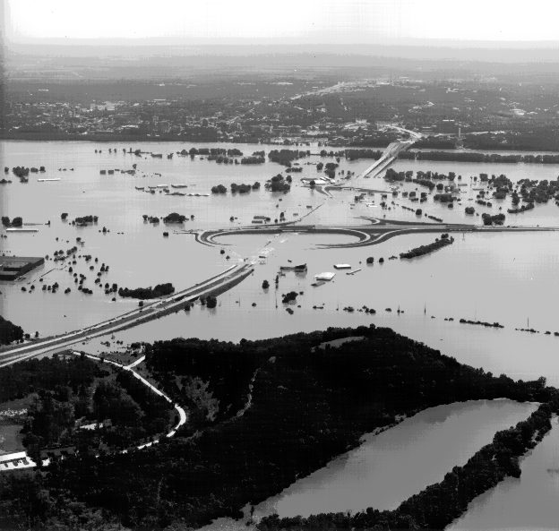
Intersection of Routes 54 & 63 in Jefferson City, Missouri, with State capitol building in the background
Mike Wright, Missouri Highway and Transportation Department Damage when flooding exceeds the containment capacity of floodwalls and levees is often catastrophic. “The added severity of the damage that occurs when a levee has been breached is not taken into account in the cost-benefit comparisons of different flood-control strategies,” says Kusler. The increase in damage has several causes. First, when water breaches or overtops a levee, it moves in with high velocity and often with little warning. People who thought they were protected are suddenly subjected to fast-moving, dangerous water. Had the levee not been there at all, the waters might have risen just as high, but they would have done so gradually and predictably, and without the force that causes the most severe flood-related damage. This effect is one of the reasons that flood-related fatalities continue to increase in the U.S., even while deaths from all other meteorological hazards are declining.
The second reason for increased severity of damage when levees fail is that the level of development on the vulnerable flood-plain tends to increase greatly due to the
perception of safety provided by the levee. This perception often occurs whether or not the levee was designed to specific standards. In many cases new residential or commercial developments are built on agricultural land “protected” only by unrated levees built by farmers. Such development is reportedly the cause of much of the recent damage in towns like Chesterfield, Missouri (see photo).
A third cause of increased damage from levee failure is that the flood waters can’t drain freely back into the river bed as the flood subsides. Periods of flooding are often prolonged because waters are trapped behind levees, creating temporary, artificial lakes. This factor not only increases the drying time needed before agricultural fields can be worked, but can also breed mosquitoes and spread disease.
Even when levees are not breached, the higher water levels they create in the river exert a pressure on subsurface water, in effect raising the groundwater level near the river. This effect has caused problems for sewage systems and saturated fields along the Colorado River in Arizona, according to FEMA.
Growing Recognition of the Need to Protect Floodplains
Since the 1960s it has increasingly been recognized that on a regional and national level, protecting floodplains from development may be more appropriate than protecting them from floods. In 1965 Congress updated federal flood-control policy, placing more of an emphasis on non-structural measures. A 1977 Executive Order by President Carter directed all federal agencies to protect floodplains and support non-structural flood-control measures.
Unfortunately, federal agencies have been less than enthusiastic in carrying out these orders. Jon Kusler points out that “there is a fascination with big projects at the Army Corps of Engineers, even though they know how to do things differently.” There has been some progress, however, in promoting non-structural approaches, particularly at the state and regional levels.
Many states whose land includes the banks of large rivers already have regulations designed to limit the size of levees and floodwalls used to prevent flooding in non-urban areas. These regulations assume that owners of floodplain property understand that their land will occasionally be under water, and that protecting it from these deluges can compromise safety downstream. “A floodplain is a natural risk area, and we can only allow a certain degree of protection without adversely affecting other areas,” says Jack Reese of the Iowa Natural Resources Council. Enforcement of these regulations is limited, however, and many levees built to higher flood levels exist illegally or predate current laws, according to Reese.
Even the Army Corps of Engineers is trying a new approach in certain instances. Most striking is the Charles River basin in eastern Massachusetts, where a $100 million plan to build dams and channelize the river was replaced by a $10 million investment in protecting the upstream wetlands. The money was used to buy acreage and easements preventing landowners from making alterations to the wetlands. According to Corps studies, this approach has performed quite well at preventing floods, and a large area of wetlands in New England’s most densely populated river basin is protected from development.
There are also federal funds allocated to reducing future flood losses by helping victims to relocate out of flood-prone areas. The best-known use of these funds was when the entire business district of Soldier’s Grove, Wisconsin, was moved after repeated flooding caused extensive damage. The relocation cost of $7.1 million was raised primarily through innovative financing. Federal funds of just under $1 million were contributed only after the town refused to accept disaster relief funds slated for standard reconstruction.
As Soldier’s Grove proved, procuring relocation funds can be difficult. They often have requirements such as matching non-federal funds. Primarily well-organized community groups and local governments have managed to take advantage of such funding so far, though legislation just introduced in Congress by delegates from Missouri (H.R. 3012) would make it easier for individuals to get help moving out of floodplains.
Recognizing the importance of allowing floodplains to flood, it makes sense to identify uses for these areas that are consistent with such a role. Agriculture can be an appropriate use of floodplains, as long as farmers can afford the periodic loss of those fields to a widening river. Floodplains often contain the most fertile soils, precisely because of their history as nutrient-rich wetlands.
In urban areas, floodplains should be reserved for uses that can afford periodic disruption from rising water. Riverside parks, recreational areas, and nature centers have all been identified as appropriate uses of floodplains in cities. These uses have the social benefit of allowing all residents to enjoy the coastal or riverside environment.
Uwe Koehler, a specialist in multi-hazard design and professor of architecture at Ball State University, has some simple principles for reducing flood losses.
•Don’t build where you can expect floods.
•Raise buildings up so that first floor is above the 100-year flood level.
•Parts of a building that are susceptible to floods should be made of materials that can get wet without damage.
When new construction projects are being designed for areas that include flood hazard areas, the floodplains should be preserved as open space. Clustering buildings to preserve open space is recommended as a way of preserving wildlife habitat and recreational areas regardless of flood hazards. The existence of the floodplain simply adds another incentive to follow this route.
When dealing with flood-damaged structures, the first approach to consider is moving, either with or without the building, out of the floodplain. Houses can usually be moved effectively if a suitable relocation site is available. If a building has suffered extensive damage, rebuilding outside the floodplain should be the first option considered. State and federal funds may be available to help with the costs of relocation, though they usually will not pay the full cost.
Reducing Damage and Impact When Building in Floodplains
When you must build in a floodplain, raising a building on columns is usually the least disruptive option. Flood insurance premiums go down when the first floor is above the level of the base-case (100-year) flood, and they drop again if it is more than three feet above flood level. As a building style, houses on columns are commonly accepted in coastal areas, but are considered odd by some inland residents. Creative landscaping and incorporating parking underneath the structure can make this option more attractive. For occupant safety, there should always be an escape from the building on high ground.
Foundations of existing houses can often be extended to raise the house. According to Koehler, this is often the most cost-effective approach, though the house must be anchored properly to the foundation. Koehler also cautions against neglecting to insulate the extended foundation properly (to conserve energy).
Basements should be designed to accept floodwaters with minimal damage. No valuable items should be stored there that can be damaged by water, and all heating equipment and electrical connections should be kept as high as possible. If possible, electrical service entries and mechanical systems should be moved to the first-floor level. Any ducts that have taken in floodwaters have to be carefully cleaned and disinfected to ensure that they won’t breed mold.
Consider using a holding tank system or another alternative to conventional in-ground septic systems, which are likely to contaminate floodwaters.
Obviously, moving everyone out of floodplains is not a realistic goal, nor is it even necessary. By protecting and regenerating natural flood-control systems outside of densely populated areas, and using structural measures around urban cores, it should be possible to reduce flood damage while actually enhancing natural ecosystems. As we consider new development, however, keeping it out of the floodplains is a worthy goal, and any new buildings in flood-prone areas should be designed with flooding in mind.